
Manaslu Trek Karte: Navigating Nepal’s Hidden Himalayan Adventure
The Manaslu Trek, also known as the Manaslu Circuit Trek, is a breathtaking journey through Nepal’s remote Himalayan landscapes, offering trekkers an unforgettable blend of natural splendor, cultural immersion, and high-altitude adventure.
Encircling Mount Manaslu, the world’s eighth-highest peak at 8,163 meters (26,781 feet), this trek is a less-traveled alternative to Nepal’s popular Everest and Annapurna routes.

The term “Manaslu Trek Karte” refers to the map or route guide essential for navigating this challenging trail, which winds through diverse terrains, remote villages, and the formidable Larkya La Pass at 5,106 meters (16,752 feet). This 2000-word article explores the Manaslu Trek Karte, detailing the route, cultural highlights, challenges, preparation tips, and why this trek is a must for adventure seekers, with a focus on the importance of a reliable karte (map) for a successful journey.
Understanding the Manaslu Trek Karte
A “karte” or map is a critical tool for the Manaslu Trek, providing a visual representation of the 177-kilometer (110-mile) circuit through the Manaslu Conservation Area. The Manaslu Trek Karte outlines the main trekking route, side trails, elevation changes, and key landmarks such as villages, monasteries, and natural features like rivers and glaciers.
Unlike more commercialized treks, the Manaslu Circuit is remote, with rugged trails and limited signage, making a detailed karte indispensable for navigation and safety. Digital and physical maps, often supplemented by GPS devices or trekking apps, help trekkers track their progress, identify rest stops, and avoid hazards like landslides or avalanches.
The trek begins in Soti Khola or Machha Khola, accessible by a 7-9 hour drive from Kathmandu, and ends in Besisahar or Chamje, connecting to the Annapurna Circuit. The Manaslu Trek Karte highlights major stops like Jagat, Deng, Samagaon, and Bimthang, as well as the high-altitude Larkya La Pass, the trek’s most challenging section. The karte also marks optional side trips, such as the Tsum Valley or Manaslu Base Camp, adding depth to the adventure.

Why the Manaslu Trek Karte is Essential
The Manaslu Trek is a restricted area trek, requiring special permits and a licensed guide, which underscores the importance of a reliable karte. Here’s why the Manaslu Trek Karte is crucial:
- Navigation in Remote Terrain: The trail traverses narrow paths, steep gorges, and high-altitude passes with minimal signage. A karte helps trekkers stay on course, especially in areas prone to landslides or snow.
- Elevation Tracking: The karte’s contour lines and elevation markers help trekkers monitor altitude gains, crucial for acclimatization and avoiding Acute Mountain Sickness (AMS).
- Cultural and Natural Landmarks: The karte pinpoints monasteries, mani walls, and natural features like Birendra Lake, ensuring trekkers don’t miss key attractions.
- Safety and Emergency Planning: In emergencies, a karte helps trekkers communicate their location to guides or rescue teams, vital in a region with limited connectivity.
- Side Trip Exploration: The karte highlights detours like Tsum Valley, allowing trekkers to plan extended adventures.

Detailed Itinerary with Manaslu Trek Karte
Below is a 16-day itinerary for the Manaslu Circuit Trek, with references to how a karte enhances the experience. The route is marked on the Manaslu Trek Karte, guiding trekkers through each stage.
- Day 1: Kathmandu to Soti Khola (700m, 8-9 hours drive)
The trek begins with a drive from Kathmandu to Soti Khola, passing through terraced fields and the Trishuli River. The karte shows the road route and the trek’s starting point. Overnight in a teahouse. - Day 2: Soti Khola to Machha Khola (870m, 6-7 hours)
The trail follows the Budhi Gandaki River, crossing suspension bridges. The karte marks bridges and landslide-prone areas, ensuring safe navigation. Overnight in Machha Khola. - Day 3: Machha Khola to Jagat (1,340m, 6-7 hours)
The path ascends through forests and Gurung villages. The karte highlights Jagat, the entry to the Manaslu Conservation Area, and a natural hot spring at Tatopani. - Day 4: Jagat to Deng (1,860m, 6-7 hours)
The trail passes Philim and enters narrower gorges. The karte shows mule trails and the Tibetan border to the north, helping trekkers orient themselves. Overnight in Deng. - Day 5: Deng to Namrung (2,630m, 6-7 hours)
The landscape shifts to alpine scenery with views of Sringi Himal. The karte marks mani walls and Namrung’s viewpoint for Ganesh Himal. Overnight in Namrung. - Day 6: Namrung to Samagaon (3,520m, 6-7 hours)
The trail passes Lho’s monastery and Shyala’s panoramic views. The karte highlights Samagaon, a key acclimatization stop, and side trips to Manaslu Base Camp. Overnight in Samagaon. - Day 7: Acclimatization Day in Samagaon
Trekkers can hike to Birendra Lake or Manaslu Base Camp (4,800m). The karte details these side trails, ensuring trekkers don’t miss these highlights. Rest in Samagaon. - Day 8: Samagaon to Samdo (3,875m, 4-5 hours)
A shorter trek to Samdo, near the Tibetan border, offers glacier views. The karte marks Samdo as the last village before the pass. Overnight in Samdo. - Day 9: Samdo to Dharmasala (4,460m, 4-5 hours)
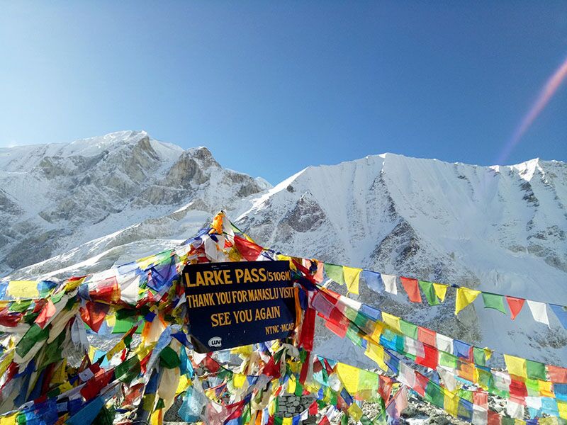
The trail ascends to Dharmasala, a basic campsite. The karte shows the route to Larkya La Pass, helping trekkers prepare for the next day’s challenge. Overnight in Dharmasala. - Day 10: Dharmasala to Bimthang via Larkya La Pass (5,106m, 8-10 hours)
The trek’s pinnacle, Larkya La Pass, offers views of Manaslu, Annapurna II, and Himlung Himal. The karte marks the steep ascent and descent to Bimthang, warning of snow risks. Overnight in Bimthang. - Day 11: Bimthang to Tilije (2,300m, 5-6 hours)
The trail descends through forests with Annapurna views. The karte guides trekkers through Gurung villages to Tilije. Overnight in Tilije. - Day 12: Tilije to Tal (1,700m, 5-6 hours)
The trail joins the Annapurna Circuit at Tal. The karte shows the Marsyangdi River and Tal’s location. Overnight in Tal. - Day 13: Tal to Syange (1,100m, 5-6 hours)
The final trekking day follows the Marsyangdi River. The karte marks Syange as the endpoint. Overnight in Syange. - Day 14: Syange to Kathmandu (1,300m, 8-9 hours drive)
A drive returns trekkers to Kathmandu. The karte’s road map ensures a smooth return. - Optional: Tsum Valley Extension (4-6 days)
A detour from Lokpa to Tsum Valley, marked on the karte, visits sacred monasteries like Mu Gompa. This adds a spiritual dimension.
Cultural Highlights on the Manaslu Trek Karte
The Manaslu Trek Karte not only guides trekkers through physical landscapes but also highlights cultural gems:
- Monasteries and Gompas: The karte marks sites like Pungyen Gompa (Samagaon) and Ribung Gompa (Lho), offering insights into Tibetan Buddhism.
- Tibetan Influence: Villages like Samdo, close to the Tibetan border, feature Buddhist chortens and mani walls, all noted on the karte.
- Gurung and Tamang Villages: Lower villages like Jagat and Tilije, marked on the karte, showcase Gurung hospitality and traditional architecture.
- Tsum Valley Culture: The karte’s Tsum Valley route highlights the unique Tsumba culture, including polyandry practices and ancient monasteries.
Challenges of the Manaslu Trek Karte
The Manaslu Trek is demanding, and the karte helps mitigate these challenges:
- High Altitude: The Larkya La Pass (5,106m) risks AMS. The karte’s elevation profile aids acclimatization planning.
- Rugged Terrain: Narrow trails and landslide-prone areas require careful navigation, guided by the karte’s hazard markers.
- Basic Facilities: Teahouses offer basic amenities, and the karte helps locate reliable lodges.
- Weather Risks: Snow or rain can block the pass, and the karte’s weather notes prepare trekkers.
- Permit Navigation: The karte shows checkpoints for permits (Restricted Area Permit, MCAP, ACAP), ensuring compliance.
Preparation Tips Using the Manaslu Trek Karte
To maximize the Manaslu Trek Karte’s utility, consider these tips:
- Study the Karte: Review the karte before trekking to understand distances, elevations, and side trips. Digital maps with zoom features are ideal.
- Physical Training: Train for 6-10 hour daily walks with a loaded backpack. The karte’s elevation data informs training needs.
- Essential Gear: Pack trekking boots, layered clothing, and a warm sleeping bag. The karte’s terrain notes guide gear choices.
- Hire a Guide: A licensed guide, mandatory for permits, complements the karte’s navigation.
- Permits: Secure Restricted Area Permit ($100/week in peak season), MCAP ($30), and ACAP ($30) through an agency. The karte shows permit checkpoints.
- Insurance: Ensure coverage for high-altitude trekking, using the karte to assess risks.
Best Time to Use the Manaslu Trek Karte
The karte is most effective during optimal trekking seasons:
- Spring (March-May): Mild weather and blooming rhododendrons enhance visibility of karte-marked landmarks.
- Autumn (September-November): Clear skies and stable conditions make the karte’s routes easy to follow.
- Avoid Monsoon (June-August): Rain and landslides obscure trails, complicating karte use.
- Winter (December-February): Snow blocks the pass, but the karte can guide lower-altitude treks.
Environmental and Ethical Considerations
The Manaslu Trek Karte supports responsible trekking:
- Leave No Trace: The karte marks waste disposal points to minimize environmental impact.
- Respect Culture: The karte highlights sacred sites, guiding trekkers to follow customs like walking clockwise around mani walls.
- Support Locals: Stay in teahouses and hire local guides/porters, as indicated on the karte’s village markers.
Why the Manaslu Trek Karte Stands Out

The Manaslu Trek Karte is more than a navigational tool—it’s a gateway to an authentic Himalayan adventure. It guides trekkers through pristine landscapes, from the Budhi Gandaki Gorge to the Larkya La Pass, while highlighting cultural treasures like Tsum Valley’s monasteries. Compared to crowded treks like Everest Base Camp, the Manaslu Circuit, as mapped by the karte, offers solitude and unspoiled beauty.
Whether you’re marveling at Manaslu’s snow-clad summit or sharing tea with a Gurung family, the Manaslu Trek Karte ensures a safe, enriching journey. So, grab your karte, lace up your boots, and embark on this extraordinary Himalayan odyssey.
Frequently Asked Questions About Larkya La Pass
1. Where is Larkya La Pass located?
Larkya La Pass is in the Gorkha District of Nepal, between Dharmasala and Bimthang on the Manaslu Circuit Trek, near Manaslu Mountain.
2. What country is Larkya La Pass in?
It’s in Nepal, part of the Manaslu Conservation Area.
3. What is the elevation of Larkya La Pass?
The elevation of Larkya La Pass is 5,160 meters (16,930 feet).
4. What is Larkya La Pass?
Larkya La Pass is the highest point of the Manaslu Circuit Trek, offering stunning views of Manaslu Peak and a challenging high-altitude crossing.
5. How do I travel from Kathmandu to Larkya La Pass?
Drive 7-9 hours from Kathmandu to Soti Khola, then trek 8-9 days through the Manaslu Circuit to reach Larkya La Pass via Dharmasala.
6. Is Larkya La Pass near Manaslu Base Camp?
Yes, Manaslu Base Camp (4,800m) is accessible as a side trip from Samagaon, a few days before crossing Larkya La Pass.
7. Are there avalanche risks at Larkya La Pass?
Mt Manaslu avalanches can occur near Larkya La Pass in winter or spring. Trek with a guide and avoid snowy seasons.
8. When is the best time to cross Larkya La Pass?
March-May and September–November for clear views and safer conditions.
9. What permits are needed for Larkya La Pass?
RAP, MCAP, and ACAP are required, costing $70-$100, with a mandatory guide.
10. How difficult is crossing Larkya La Pass?
It’s strenuous, requiring fitness for a long, high-altitude day (5,160m) with steep ascents and descents.