

The Mardi Himal Trek is a newer trekking route in Nepal’s Annapurna region that provides breathtaking views of Machhapuchhre (Fishtail), Annapurna South, Hiunchuli, and other Himalayan peaks. Depending on your itinerary and the weather, the trek usually ends at either the Mardi Himal Viewpoint (~4,500m) or High Camp (~3,580m).
After starting close to Pokhara and taking a quick drive to Kande or Phedi, the route progressively climbs through villages, ridgelines, and forested slopes to Low Camp, High Camp, and the Mardi Himal Base Camp/Viewpoint. Trekkers follow the same path back to Pokhara after admiring the stunning scenery.
For people with limited time who wish to take a quick but immersive walk through the Himalayas, Mardi Himal is perfect. The trail is suitable for intermediate hikers and even some first-time trekkers because it blends natural beauty, cultural exposure, and a moderate level of physical difficulty.
Highlights of Mardi Himal Trek
- Close-up Himalayan Views: Trekkers can get striking views of Machhapuchhre, Annapurna South, Hiunchuli, and other peaks from the ridges and base camp areas.
- Diverse Landscapes: The walk offers a distinctive fusion of subtropical, temperate, and near-alpine terrain as it travels through open hillsides, alpine meadows, and dense oak, rhododendron, and bamboo forests.
- Less Crowded: Compared to Annapurna Base Camp or Poon Hill, Mardi Himal is a more recent route that sees significantly fewer hikers, offering seclusion and a more genuine mountain experience.
- Short Duration: Depending on pace and rest, the trek can be finished in 5–9 days, making it ideal for time-constrained travellers.
- Teahouse Accommodation: By offering food and shelter, cosy lodges and teahouses along the trail minimise the need for camping equipment.
- Cultural Experience: Trekkers can get a taste of traditional mountain life in Nepal by following the trail through the villages of Gurung and Magar.
- Opportunities for Photography: Ridge-top camps provide breathtaking views of the Annapurna range at sunrise and sunset.
- Budget-Friendly: Travellers on a tight budget can complete the trek because there are teahouse accommodations and no costly flights are needed.
- Accessible from Pokhara: It is logistically simple to get to the trailhead from Pokhara because it is only a short drive away.
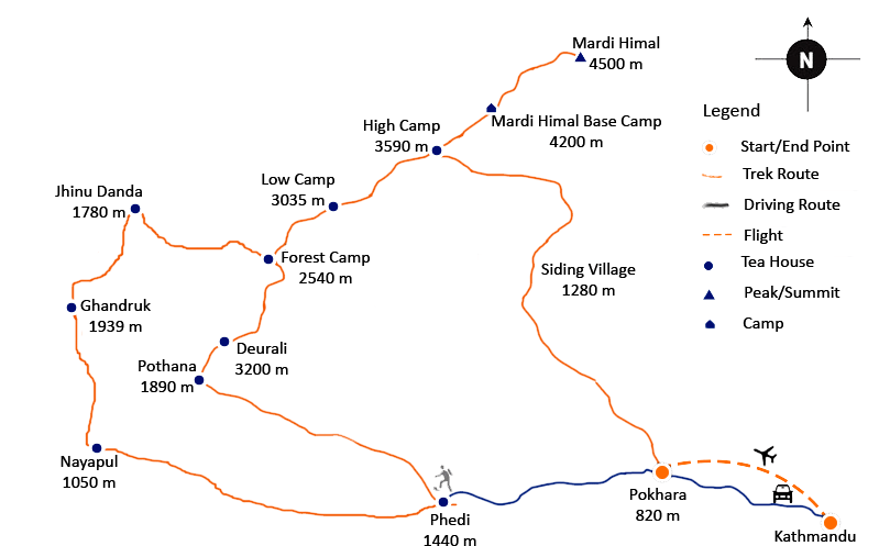
Typical Mardi Himal Trek Itinerary (6–9 Days)
Depending on available time, interests, and level of fitness, the trek may be shortened or prolonged. Altitude gain is the biggest obstacle, with a total distance of about 30 to 45 km.
| Day | Route / Activity | Altitude / Notes |
|---|---|---|
| 1 | Drive Pokhara → Kande → Trek to Deurali / Pothana | ~2,100 m — easy start |
| 2 | Trek Deurali → Forest Camp | ~2,500 m |
| 3 | Forest Camp → Low Camp | ~2,970–3,100 m |
| 4 | Low Camp → High Camp | ~3,550–3,580 m — acclimatization begins |
| 5 | High Camp → Viewpoint / Mardi Himal Base Camp → return High Camp | ~4,200–4,500 m |
| 6 | Descend High Camp → Forest / Siding → drive back to Pokhara | ~1,700–1,800 m |
| 7–9 | Optional: explore villages, relax in Pokhara, or extend trekking |
Detailed Mardi Himal Trek Map and Itinerary
The trekking route from Pokhara to the Mardi Himal Base Camp or Viewpoint is clearly depicted on the Mardi Himal Trek Map.
With the help of this map, hikers can effectively plan their route by knowing important stops, altitude, and distances. A standard 6–9 day schedule based on the Mardi Himal Trek Map is shown below:
Day 1: Drive from Pokhara to Kande or Phedi, trek to Deurali
- Altitude: ~2,100 meters
- As you begin your journey from Kande, you progressively ascend through small villages and terraced fields, preparing your legs for higher elevations. The trail opens onto ridgelines with far-off views of Annapurna South after passing through thick forests.
Day 2: Trek from Deurali to Forest Camp
- Altitude: ~2,500 meters
- The route passes through verdant rhododendron and oak forests. Bamboo thickets and sporadic waterfalls might be visible. There are both mild inclines and moderate climbs on the trail.
Day 3: Trek from Forest Camp to Low Camp
- Altitude: 2,970–3,100 meters
- The Gurung community lives in small hamlets along the steeper trail. Trekkers are rewarded with expansive views of Hiunchuli and Machhapuchhre along the route. The Low Camp is a great place to spend the night resting and acclimatising.
Day 4: Trek from Low Camp to High Camp
- Altitude: 3,550–3,580 meters
- From Low Camp to High Camp, the Mardi Himal Trek Map shows a steep climb where hikers start to experience the high-altitude environment. Alpine meadows appear along the trail, and snow-capped peaks dominate the horizon.
Day 5: High Camp to Mardi Himal Base Camp/Viewpoint, return to High Camp
- Altitude: 4,200–4,500 meters
- This is the high point of the trek. The trail ascends from High Camp to the Mardi Himal Base Camp or the Viewpoint, which provides unhindered views of Hiunchuli, Machhapuchhre, and the Annapurna range. For the purpose of visualising the final ascent and important viewpoints, this section of the Mardi Himal Trek Map is essential. Trekkers return to High Camp for the night after taking in the scenery.
Day 6: Descend from High Camp to Forest Camp/Siding, drive back to Pokhara
- Altitude: 1,700–1,800 meters
- Trekkers can see the trail and villages from a different angle thanks to the quicker descent. Trekkers return to Pokhara after a quick drive from the trailhead.
Optional Days 7–9:
- In Pokhara, hikers can explore neighbouring villages, unwind by Phewa Lake, or continue their journey to more ridgelines or vantage points.
Best Seasons for Mardi Himal Trek
You can schedule the best times to go trekking:
- Spring (March–May): Clear skies, moderate temperatures, and blooming rhododendrons
- Autumn (September–November): Great views of the mountains, crisp air, and consistent weather
- Winter (December–February): colder, fewer hikers; High Camp may see snowfall
- Monsoon (June–August): Loss of visibility and landslip risk
Why Use the Mardi Himal Trek Map?
The Mardi Himal Trek Map is very useful for:
- Organising daily routes and altitude increases.
- locating viewpoints, camps, and teahouses.
- recognising the changes in terrain and the difficulty of the trail.
- envisioning optional extensions or side trips.
- tracking your position while hiking to increase safety.
Safety Tips
Make sure you’re safe by using the Mardi Himal Trek Map:
- Get used to both Low and High Camps.
- Bring warm layers and rainproof clothing.
- For stability on rocky or steep terrain, use trekking poles.
- Before drinking, hydrate and purify the water.
- It is advised to have travel insurance that covers helicopter evacuation.
- There are no ATMs on the trail, so carry cash.
Conclusion
Trekkers can clearly see one of the most picturesque and less-travelled routes in the Annapurna region with the help of the Mardi Himal Trek Map.
This trek blends adventure, culture, and photography opportunities with breathtaking views of Machhapuchhre, Annapurna South, Hiunchuli, alpine forests, and real Gurung villages.
For hikers of all skill levels, the journey is rewarding, whether your goal is the Mardi Himal Viewpoint or High Camp.
The Mardi Himal Trek is an excellent substitute for congested trekking routes because it is affordable, accessible from Pokhara, and suitable for a brief period of time.
Safe navigation, the best possible planning, and the complete enjoyment of this Himalayan treasure are all ensured by using a Mardi Himal Trek Map.
Frequently Asked Questions
What is the Mardi Himal Trek?
In Nepal’s Annapurna region, the Mardi Himal Trek is a moderate trekking route that offers breathtaking views of the surrounding Himalayan peaks, Machhapuchhre, Annapurna South, and Hiunchuli.
Where does the Mardi Himal Trek start?
After a quick drive to Kande or Phedi, the trail progressively climbs to Low Camp, High Camp, and the Mardi Himal Base Camp or Viewpoint. The trek usually begins close to Pokhara.
How long is the Mardi Himal Trek?
Depending on the chosen itinerary and daily pace, the trek typically takes 5–9 days and covers 30–45 km.
What is the highest point on the Mardi Himal Trek?
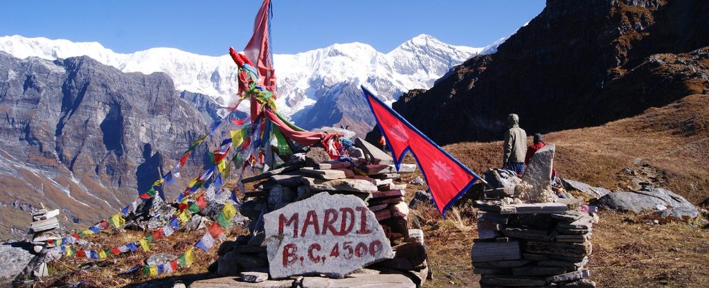
At about 4,500 metres, the Mardi Himal Base Camp or Viewpoint is the highest point.
What permits are required for the Mardi Himal Trek?
A Trekkers’ Information Management System (TIMS) card and an Annapurna Conservation Area Permit (ACAP) are required for hikers.
When is the best time for the Mardi Himal Trek?
The best times of year are autumn (September–November) for stable weather and clear skies, and spring (March–May) for rhododendron blooms.
What level of fitness is required for the Mardi Himal Trek?
Due to the trek’s steep sections, high-altitude hiking, and steady climbs, moderate fitness is advised.
Is teahouse accommodation available on the Mardi Himal Trek?
Yes, all camps have comfortable lodges and teahouses with basic amenities, tea, and meals.
Can beginners do the Mardi Himal Trek?
Although acclimatisation at High Camp is crucial, novice hikers with a moderate level of fitness can finish the trek.
How can I use the Mardi Himal Trek Map?
The Mardi Himal Trek Map facilitates route planning, daily distance tracking, camp and village location, and viewpoint identification for photography or rest stops.