
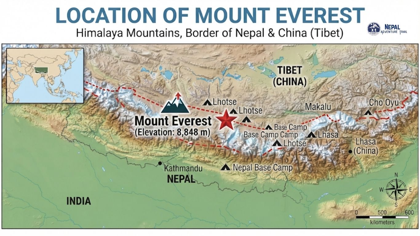
The Everest does not belong to one side of a map. It rises on the Himalayan frontier between Nepal and the Tibet Autonomous Region of China, and the international boundary passes over its summit. Nepal holds the southern approach, with its sherpa villages, glaciers, and a walking trail that starts at Lukla. Tibet holds the northern approach, with a road that reaches a base camp near Rongbuk Monastery.
Understanding the Mount Everest location properly means holding both ideas at once. The mountain is on the border, and it can be reached from either country by very different routes. This guide answers the basic question first, then works outward to coordinates, administrative geography, base camps, distances and how travellers actually get there.
Where Is Mount Everest Located? Quick Answer
Mount Everest is in the Himalayas in Asia, on the border between Nepal and Tibet, China. On the Nepal side it lies in the Khumbu region of Solukhumbu District, Koshi Province, inside Sagarmatha National Park. On the Tibet side it lies in Tingri County, Xigazê (Shigatse) Prefecture. Its summit stands at 8,848.86 m (29,031.7 ft) according to the 2020 joint Nepal and China measurement, at about 27°59′17″N, 86°55′31″E. It is the highest mountain above sea level on Earth.
Mount Everest Location at a Glance
| Feature | Information |
|---|---|
| Mountain | Mount Everest |
| Nepali name | Sagarmatha |
| Tibetan name | Chomolungma (Qomolangma in Chinese romanisation) |
| Location | Nepal and Tibet (China) border |
| Southern side | Nepal, Koshi Province, Solukhumbu District |
| Northern side | Tibet Autonomous Region, China, Tingri County |
| Mountain range | Himalayas, Mahalangur Himal sub-range |
| Region | Khumbu (Everest region) |
| Elevation | 8,848.86 m (2020 joint measurement); 8,848 m widely used |
| Coordinates | About 27°59′17″N, 86°55′31″E (27.9881°N, 86.9250°E) |
| Protected areas | Sagarmatha National Park (Nepal); Qomolangma National Nature Preserve (Tibet) |
Where Is Mount Everest on the Map?
On a map of Asia, find the Himalayan arc that curves above the Indian subcontinent. Near its centre, where Nepal meets the Tibetan Plateau, the range carries a cluster of the highest peaks on Earth. Everest sits among them, at a latitude near 28°N, close to that of Delhi, though separated from it by the whole breadth of the Himalayan foothills. Nepal lies to the south and the Tibetan Plateau opens to the north.
Looking from Kathmandu, the mountain is to the east-northeast. Looking from the Nepal side, the approach climbs north through the Dudh Koshi valley into the Khumbu. From Tibet, the view starts on a plateau at around 5,000 m and looks south at the north face.
Mount Everest Location in Nepal
From Nepal’s point of view, Everest is in the north-east of the country. The administrative chain is Koshi Province, Solukhumbu District and Khumbu Pasang Lhamu Rural Municipality, according to current administrative references, and the entire area lies inside Sagarmatha National Park. Administrative names have changed in recent years, so it is worth checking the latest official designation if you need it for a document.
The surrounding peaks define the setting. Lhotse (8,516 m) rises beside Everest, with Nuptse (about 7,861 m) just to the west-southwest, and Cho Oyu and Makalu lie within the same high massif. The Khumbu region is the best-known populated part of the Mahalangur Himal, because it holds the access trail to the South Col route.
Is Mount Everest in Nepal or China?
Neither answer is complete. The summit sits on the boundary, so both countries have a side of the mountain. Nepal is on the south and China on the north. People associate Everest with Nepal because most trekkers and many climbers approach from the Nepal side, and because the Nepali name Sagarmatha is the official Nepali designation. China’s side is called Qomolangma, and both names are used in their own language. Geography here is simple. The politics of the border are not the subject of this guide.
Is Mount Everest in Nepal or Tibet?
Both. Tibet is an autonomous region of China, and Everest’s northern side is in Tibet. The mountain’s southern side is in Nepal. The summit lies on the international boundary between the two.
Mount Everest on the Nepal-China Border
The border runs along the crest of the Himalaya here. Everest is one of the high points on that crest, and the boundary line passes over the summit. This is why the mountain can be climbed from two directions. On the Nepal side, the usual route goes up the Khumbu Glacier and the Western Cwm to the South Col. On the Tibet side, the usual route goes up the Rongbuk Glacier to the North Col and the northeast ridge. The experience differs in access, terrain, weather exposure and paperwork.
Nepal Side vs Tibet Side of Everest
| Feature | Nepal Side | Tibet Side |
|---|---|---|
| Geographic position | Southern slope | Northern slope |
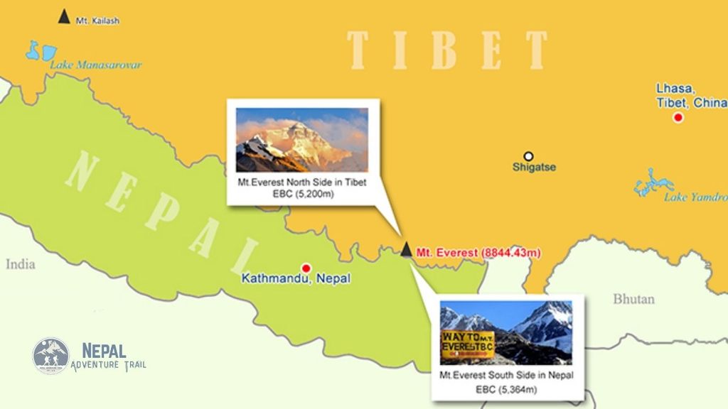
| Base camp | South Base Camp, about 5,364 m | North Base Camp, about 5,150 m |
| Typical access | Fly to Lukla, then walk for several days | Overland by road from Lhasa or Shigatse, subject to permits |
| Landscape | Forested valleys, Sherpa villages, glacier | High plateau, open valleys, Rongbuk Monastery |
| Trekking experience | Multi-day teahouse trek | Mostly vehicle-based visit |
| Mountaineering approach | Khumbu Glacier, South Col route | Rongbuk Glacier, North Col route |
| Protected area | Sagarmatha National Park | Qomolangma National Nature Preserve |
| Travel requirements | Nepal visa, park permit and local fee; check current trekking rules | Chinese visa, Tibet Travel Permit and further permits arranged through an agency |
Where Is Everest Base Camp Located?
There are two. Neither is at the summit, and both are far lower.
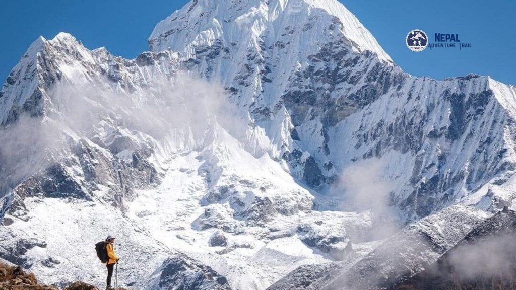
South Base Camp (Nepal) is in the Khumbu region of Solukhumbu, in Sagarmatha National Park, at about 5,364 m. Trekkers reach it from Lukla via Namche Bazaar, Tengboche, Dingboche and Lobuche, and usually stay overnight at Gorak Shep, about 5,164 to 5,180 m depending on the source. Trekkers generally do not camp at Base Camp itself.
North Base Camp (Tibet) is in Tingri County near Rongbuk Monastery, at roughly 5,150 m. A road reaches the tourist area, so it is possible to arrive by vehicle. Visitors need a Chinese visa and permits arranged through a registered agency.
Is Everest Base Camp in Nepal? The famous trekking Base Camp is. The northern one is not.
Where Is Mount Everest Relative to Kathmandu?
Everest is east-northeast of Kathmandu. Published straight-line distances range from about 140 km to 160 km depending on source and measuring points, so treat any single figure as approximate. That distance is not a road distance, and it does not describe travel time. No road reaches the Nepal side, so travellers usually fly to Lukla and walk. Kathmandu is the gateway, not the neighbour.
Where Is Mount Everest Relative to Lukla?
Lukla (2,860 m) is the usual entry point to the Khumbu, with a short mountain airstrip. It is not near the summit. From there the classic trail climbs north through Phakding, Namche Bazaar and onward, rising more than 2,500 m over several days to Base Camp. Lukla is a gateway, not a view of Everest.
Nearest Towns and Settlements to Mount Everest
“Nearest” depends on how you measure. In straight-line terms, small high settlements and monastery sites near the glacier are closest. On the standard trekking route, the key stops are Lukla, Namche Bazaar (about 3,440 m, the Sherpa trading hub), Tengboche (monastery), Dingboche, Lobuche and Gorak Shep, the last lodge settlement before Base Camp. Namche and Lukla are important, but neither sits close to the mountain.
What Mountain Range Is Mount Everest In?
Everest is in the Himalayas, in the Mahalangur Himal sub-range, which also holds Lhotse, Makalu and Cho Oyu, four of the world’s six highest peaks. It is not part of the Annapurna range, which lies to the west in central Nepal.
Mount Everest Elevation and Coordinates
Elevation. The accepted height is 8,848.86 m (29,031.7 ft), announced jointly by Nepal and China in 2020. Many sources, including Nepal Tourism Board geography pages, still list 8,848 m. Both appear, and the second is the older rounded figure. Use 8,848.86 m when precision matters.
Coordinates. About 27°59′17″N, 86°55′31″E, or 27.9881°N, 86.9250°E in decimal degrees. Some references round the seconds to 18″ or 30″, so you may see tiny differences between sources. They describe the same point.
Why Is Mount Everest Called Sagarmatha and Chomolungma?
Nepal calls the mountain Sagarmatha, a name commonly translated as head of the sky. Tibetans call it Chomolungma (Qomolangma), often rendered as Holy Mother. The English name honours George Everest, a former Surveyor General of India. Before that the mountain was recorded in the British survey as Peak XV. These are three names for one mountain.
Sagarmatha National Park and Mount Everest
Sagarmatha National Park protects the Nepal side of the Everest region and was added to the UNESCO World Heritage list in 1979. Its elevation runs from the lower valleys to the summit. It holds Sherpa communities, monasteries, glaciers and high alpine terrain. Trekkers pay a park entry fee and, in the Khumbu, a local municipality fee. Published figures are about NPR 3,000 for the park and between NPR 2,000 and 3,000 for the local fee, but confirm before travel.
How to Reach Mount Everest from Nepal
You do not drive to Everest from Kathmandu. For trekkers the standard route is Kathmandu to Lukla by air, then a walk through the Khumbu to Base Camp, typically over about a week or more with acclimatisation days. In peak seasons, Lukla flights have often departed from Manthali in Ramechhap, so confirm departure details. Summit climbers need an expedition permit and a far more complex plan. Sightseeing travellers can fly over the region on a scenic flight or helicopter tour, which is a different product from trekking.
For the Tibet side, you need a Chinese visa, a Tibet Travel Permit and further border-area permits through an agency. Rules differ by side and by trip type, so verify current requirements before booking.
What Everest’s Location Means for Your Trip
The geography shapes the logistics. Nepal is the common gateway for the classic trekking experience, and the journey combines air travel with several days on foot. Altitude is the real constraint: Base Camp sits above 5,000 m, so acclimatisation days are part of the plan, not a bonus. Tibet is reached by a different route, with different permits and a more vehicle-based visit. Requirements depend on the side you choose and on the type of trip, and they change, so confirm them before you book.
If you are weighing a trek, a scenic flight or a Tibet-side visit, a local operator such as Nepal Adventure Trail can explain how each route relates to the mountain’s actual position and help match the plan to your time and fitness.
Everest Region Geography and Climate
The land climbs fast. Forested valleys at Lukla give way to alpine terrain above Namche, then glacier, moraine and rock at Gorak Shep. Temperature drops roughly 6°C for every 1,000 m gained, a broad rule rather than a forecast. The upper region is cold, windy and snow-covered much of the year, while the lower Khumbu is milder. The mountains are not equally accessible all year, so seasons matter for a visit.
Common Misconceptions About Everest’s Location
- “Everest is completely in Nepal.” The summit is on the Nepal-Tibet boundary.
- “Everest is in Tibet only.” Nepal has the southern slope and a major climbing and trekking approach.
- “Base Camp is at the summit.” Base Camps are at roughly 5,150 to 5,364 m. The summit is 8,848.86 m.
- “Lukla is next to Everest.” Lukla is the starting gateway, days of walking away.
- “Everest is in the Annapurna range.” It is in the Mahalangur Himal.
- “Sagarmatha is a different mountain.” It is the Nepali name for Everest.
Frequently Asked Questions
Where is Mount Everest located?
In the Himalayas, on the border between Nepal and Tibet, China. The southern side is in Solukhumbu District, Koshi Province, Nepal, inside Sagarmatha National Park. The northern side is in Tingri County, Tibet.
Which country is Mount Everest in?
Two countries share it. The summit lies on the boundary between Nepal and China, so the southern slope is Nepal’s and the northern slope is in the Tibet Autonomous Region.
Is Mount Everest in Nepal or China?
Both, in a sense. The border passes over the summit. Most trekkers approach from Nepal, which is why people associate the mountain with Nepal.
Is Mount Everest in Nepal or Tibet?
Nepal holds the southern side and Tibet, an autonomous region of China, holds the northern side. The summit stands on the boundary.
What is the exact location of Mount Everest?
About 27°59′17″N, 86°55′31″E, in the Mahalangur Himal of the Himalayas. Slight rounding differences appear between sources.
What are the coordinates of Mount Everest?
Roughly 27.9881°N, 86.9250°E in decimal degrees, or 27°59′17″N, 86°55′31″E in degrees, minutes and seconds.
What is Mount Everest’s altitude?
8,848.86 m (29,031.7 ft) in the 2020 joint Nepal and China measurement. The older rounded figure of 8,848 m still appears widely.
Which district is Mount Everest in?
On the Nepal side, Solukhumbu District, within Khumbu Pasang Lhamu Rural Municipality. Check current official designations because local boundaries have changed.
Which province is Mount Everest located in?
Koshi Province on the Nepal side. On the Chinese side it is in the Tibet Autonomous Region.
Where is Everest Base Camp located?
South Base Camp is in Nepal’s Khumbu region at about 5,364 m. North Base Camp is in Tibet at roughly 5,150 m. Neither is at the summit.
How far is Mount Everest from Kathmandu?
About 140 to 160 km east-northeast in a straight line, depending on the source. Reaching it takes days, because no road runs to the Nepal side.
How do you reach Mount Everest from Nepal?
Fly from Kathmandu to Lukla, then trek through Namche Bazaar and the Khumbu to Base Camp. Climbers need expedition permits, and sightseeing flights are available without trekking.