
Nepal adventure travel is not one experience. It is a dozen different countries stacked inside one set of borders. A trekker in Upper Mustang eats apricots grown on a Tibetan plateau, while a rafter three days south fights whitewater through a Terai jungle at 200 meters elevation, and both of them call it the same trip.
This guide breaks down the regions that stand as genuinely safe, well-monitored choices for Nepal adventure travel through 2026 and 2027, region by region, with the physical realities each one demands. We’ve left a few areas out deliberately. Parts of Rasuwa, Langtang, and the Gosaikunda-Tamang Heritage corridor sustained serious flood damage in August 2026, and access there remains unconfirmed as repair work continues; we’ll cover those separately once conditions stabilize rather than guess at their status here. Every region covered below has stable road access, functioning infrastructure, and no unresolved disaster-recovery work as of this writing.
The Geography Behind Nepal Adventure Travel Regions
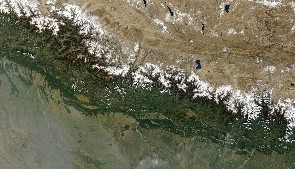
Nepal packs more vertical range into 800 kilometers than almost any country on earth. Elevation runs from under 100 meters in the Terai lowlands to 8,849 meters at the summit of Everest. That range is the entire reason Nepal adventure travel varies so wildly from one trailhead to the next and why a “safe trek” means something different in each zone.
Three bands run roughly parallel, east to west, across the country. The Terai holds flat jungle and grassland near the Indian border. The mid-hills climb through terraced farmland and forest. The high Himalaya close out the north in permanent snow and rock.
Terrain Zones and What They Mean for Trekkers
Walking north from a Terai jungle lodge to a high Himalayan base camp means crossing every major biome Nepal has, sometimes within a single week-long itinerary. Air gets thinner. Villages get sparser. Stone replaces wood as the primary building material somewhere around 3,000 meters, a shift you can track just by watching how teahouse walls change color and texture along the trail.
Rivers cut the whole system into separate valleys, and those valleys behave like separate countries culturally as much as physically. The Kali Gandaki gorge, the Budi Gandaki, the Karnali, the Arun: each one carries its own trade history, its own ethnic mix, its own architecture. A trekker moving between two adjacent valleys often notices the change in language and roof style before they notice the change in altitude.
Historical Trade Routes Behind Today’s Trekking Trails
Most of Nepal’s trekking trails did not start as tourist paths. They started as salt routes, pilgrim paths, or trade corridors linking Tibet to the Indian plains long before trekking existed as an industry.
The Kali Gandaki, running through what’s now the Annapurna region, carried salt caravans from Tibet for centuries, and Mustang’s economy still carries traces of that trade history in its architecture and language. Manaslu’s circuit followed a similar Tibetan trade corridor, which is part of why the region retains such strong Tibetan Buddhist cultural character despite sitting fully inside Nepal’s borders. Understanding a region’s trade history usually explains its trail layout better than any modern map does.
Region by Region: Where Nepal Adventure Travel Remains Safe and Stable
Every one of these regions carries a current, stable safety profile for 2026 and 2027, drawn from road access, permit office function, and infrastructure condition rather than marketing claims. Knowing each region’s physical signature before booking saves trekkers from the wrong gear list and the wrong expectations.
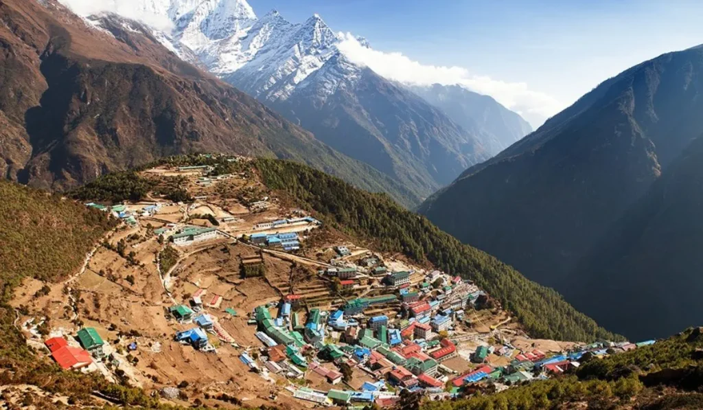
Everest and the Khumbu region sits at the top of most bucket lists, and for good reason: no other trek combines this much high-altitude drama with this much built infrastructure. Stone teahouses line the trail from Lukla to Base Camp, spaced close enough that solo trekking here is realistic in a way it isn’t in most of Nepal. Access runs through Lukla by air, entirely separate from the flood-affected northern road corridors, and altitude is the real hazard here, not terrain difficulty, with the trail climbing past 5,000 meters at Kala Patthar and the Everest Base Camp site itself.
The Annapurna region offers the widest range of trip lengths of any area in Nepal, from the four-day Poon Hill loop to the three-week full Annapurna Circuit. Rhododendron forest gives way to alpine desert within a matter of days on routes like the Annapurna Circuit, which crosses the Thorong La pass at 5,416 meters. Road construction has reached deeper into this region than almost anywhere else in Nepal, a fact that has shortened some classic routes but also means access roads here are well maintained and regularly used, pushing serious trekkers toward the higher, quieter side trails for solitude rather than out of any access concern.
Upper Mustang, a restricted area requiring a special permit, feels closer to the Tibetan plateau than to the rest of Nepal. Wind-scoured cliffs, cave dwellings carved into red sandstone, and the walled city of Lo Manthang define a landscape that gets barely 300mm of annual rainfall. This is high-desert trekking, not jungle-to-alpine trekking, and its arid climate means the region carries essentially none of the flash-flood and landslide risk that affects Nepal’s wetter northern valleys.
The Manaslu Circuit runs through some of the least developed trekking infrastructure of any popular route in Nepal, requiring a restricted-area permit and, in most cases, a licensed guide by law. The trail follows the Budi Gandaki through steep gorge sections before crossing the Larkya La at over 5,100 meters, and teahouses here remain basic compared to Everest or Annapurna standards. The Budi Gandaki is a separate watershed from the Trishuli and Bhote Koshi systems affected by the 2026 Rasuwa flood, and Tibetan Buddhist culture runs deep in the upper villages, visible in the mani walls and gompas that line the final approach to the pass.
Kanchenjunga and Makalu, in Nepal’s far east, sit among the least-trekked major regions in the country despite bordering two of the world’s highest peaks. Both require restricted-area permits, both demand full camping logistics rather than teahouse trekking, and both reward trekkers with a level of isolation that has mostly disappeared from the central trekking corridors, with no infrastructure disruption reported in either region.
Far-Western Nepal, including Rara Lake and the Api-Nampa region, remains the least developed adventure travel zone in the country by almost every measure. Rara sits beside Nepal’s largest lake within a national park of the same name, reached by flights into Talcha airstrip followed by several days of trekking through forest largely untouched by commercial trekking traffic. Infrastructure here is closer to what Everest looked like decades ago than to what it looks like today, and the region sits well outside the river systems affected by this year’s flooding further east.
The Terai lowlands, including Chitwan and Bardia National Parks, offer an entirely different register of Nepal adventure travel: jungle safari on elephant-back or jeep, rhino and tiger tracking on foot with trained guides, and river rafting through grade III and IV whitewater on rivers including the lower Trishuli, well downstream of the 2026 flood zone, and the Karnali. These destinations pair naturally with a mountain trek, since Kathmandu, Pokhara, and the Terai sit close enough together for a single trip to cover jungle and alpine terrain within two or three weeks.
Infrastructure and Logistics Across These Regions
Permit rules vary sharply by region, and this is where trip planning most often goes wrong. Everest and Annapurna require a TIMS card and, for Annapurna, an ACAP permit; Manaslu, Upper Mustang, and Kanchenjunga all require restricted-area permits that cost significantly more and, in most cases, mandate a licensed guide.
Teahouse density drops fast as you move from the classic routes to the remote ones. Everest and Annapurna offer teahouses every few hours of walking. Manaslu spaces them further apart. Kanchenjunga, Makalu, and Far-Western Nepal require camping gear for most of the trip, since teahouses simply don’t exist in enough villages to support a walk-in-walk-out itinerary.
Field Realities: Gear, Food, and Daily Rhythm
Dal bhat remains the backbone meal across nearly every trekking region in Nepal, and for good reason: rice, lentils, and vegetables refilled without extra charge give trekkers the calories a long climbing day demands. Above 3,500 meters, menus thin out fast, and travelers should expect fewer choices the higher they climb.
Cold mornings define the rhythm of high-altitude trekking regardless of which valley you’re in. Boots go on stiff from overnight cold. Breath fogs in unheated teahouse dining rooms before the first cup of tea arrives. That rhythm, more than any single landmark, is what most experienced trekkers remember first when they think back on a completed route.
Community Impact and Local Economies
Trekking tourism is the primary cash economy in most of these regions, and the difference between a well-managed trekking group and a poorly managed one shows up directly in local livelihoods. Porter wages, teahouse income, and guide employment all depend on trekking volume holding steady through the main seasons, which is one more reason steering clients toward genuinely stable regions matters this year.
Restricted-area permit fees, in regions like Upper Mustang, Manaslu, and Kanchenjunga, feed directly into local development funds rather than general government revenue. That fee structure exists specifically because these areas sit close to sensitive border zones and carry fragile cultural heritage that unrestricted tourism could damage quickly.
Traveler Realities: Timing, Weather, and Safety for 2026-2027
Two windows work for nearly every trekking region covered here: pre-monsoon spring, roughly March through May, and post-monsoon autumn, roughly late September through November. Both offer stable weather and clear mountain visibility, with autumn generally holding the edge for consistency.
Winter closes high passes across Manaslu, Annapurna, and Everest with snow, though lower routes and the Terai stay accessible year-round. Monsoon, from June through September, turns most mid-hill trails muddy and leech-heavy while closing visibility on nearly every high route, though Upper Mustang, sitting in a rain shadow, remains one of the few regions genuinely trekkable through the summer months.
Seasonal Windows by Region
Everest and Annapurna both peak in October and November, when the trails carry their heaviest foot traffic of the year. Manaslu and the restricted eastern regions see far lighter crowds in the same window, a direct result of higher permit costs and mandatory guide requirements filtering out casual trekkers.
Rara Lake and the Far-Western routes hold a narrower safe window than the central regions, largely closed by snow from December through February and best walked between April and June or September through November. Upper Mustang’s rain-shadow climate makes it the rare region where a June or July departure still makes practical sense.
Field Safety Protocols
Altitude sickness remains the single biggest risk across every high-altitude region in this guide, and it does not respect fitness level. Trekkers moving above 3,000 meters should build in acclimatization days regardless of route, watch for headache, nausea, and unusual fatigue, and treat any worsening symptom as a signal to descend rather than push through.
River crossings and landslide-prone sections deserve specific caution during and immediately after monsoon rain, a risk that recent flooding in Nepal’s northern valleys has underscored sharply. None of the regions detailed in this guide share the specific river systems affected by that event, but the underlying pattern applies anywhere trekking routes run beside glacially fed rivers. Trekking with a guide who maintains contact with local authorities and current trail conditions matters most in remote regions like Kanchenjunga, Makalu, and Far-Western Nepal, where help is genuinely far away if something goes wrong.
Frequently Asked Questions
Which regions are considered safe for Nepal adventure travel in 2026 and 2027?
Everest, Annapurna, Upper Mustang, Manaslu, Kanchenjunga, Makalu, Far-Western Nepal, and the Terai lowlands all currently have stable road access and no unresolved disaster-recovery work, unlike parts of Rasuwa and Langtang.
Why are Rasuwa and Langtang excluded from this guide?
An August 2026 flash flood caused significant infrastructure damage in that corridor, and road and trail conditions there remain unconfirmed as repair work continues.
Which Nepal adventure travel destination is best for a first-time trekker?
The Annapurna region, particularly the Poon Hill or Ghorepani loop, offers strong infrastructure, shorter trip lengths, and a gentler altitude profile than Everest or the restricted regions.
Do all trekking regions in Nepal require a guide?
No. Independent trekking remains legal on Everest and Annapurna’s main routes, but Manaslu, Upper Mustang, Kanchenjunga, and Makalu all require a licensed guide by regulation.
How much do restricted-area permits cost compared to standard permits?
Restricted-area permits run substantially higher than TIMS or ACAP fees, often calculated per person per day, with Upper Mustang and Kanchenjunga among the more expensive options.
Is Everest Base Camp harder than the Annapurna Circuit?
They test different things. Everest Base Camp involves greater altitude exposure with less overall distance, while the Annapurna Circuit covers more ground and a wider range of terrain and climate zones.
Can I combine a mountain trek with a jungle safari in one trip?
Yes. Chitwan and Bardia sit close enough to Kathmandu and Pokhara that a combined mountain-and-jungle itinerary across two or three weeks is a common and practical trip structure.
Are teahouses available on every trekking route in Nepal?
No. Everest, Annapurna, and most of the Manaslu Circuit offer teahouse trekking. Kanchenjunga, Makalu, and much of Far-Western Nepal require camping gear and a support crew.
What should I pack differently for Upper Mustang compared to Everest?
Upper Mustang’s dry, wind-exposed climate calls for stronger sun and wind protection with less emphasis on heavy insulation than Everest’s colder, wetter high-altitude conditions demand.
Ready to Choose Your Region
Navigating the changing topography and deep cultural cycles of Nepal requires more than a map; it demands real-time awareness, regional networks, and uncompromising safety standards. At Nepal Adventure Trail, we prioritize your security and immersion above all else, continuously managing permits, route integrity, and logistics across the Himalayas. Let us guide you through the mountains with the preparation and caution these regions demand.