A route map answers the questions that matter before you book anything. Where does the walking start? How quickly does the altitude climb? Which villages are sleeping stops and which are only tea breaks? Where does Everest Base Camp actually sit, and where does Kala Patthar fit in?
This Mount Everest route map guide follows the classic trekking route from Lukla to Everest Base Camp, stop by stop, with elevations, approximate distances, and walking times. It also clears up the most common confusion. The trail on the map takes you to the foot of the Khumbu Icefall. It does not go to the summit. Figures here are given as ranges where reliable sources disagree, because elevations and distances vary slightly by survey and by how a route is measured.
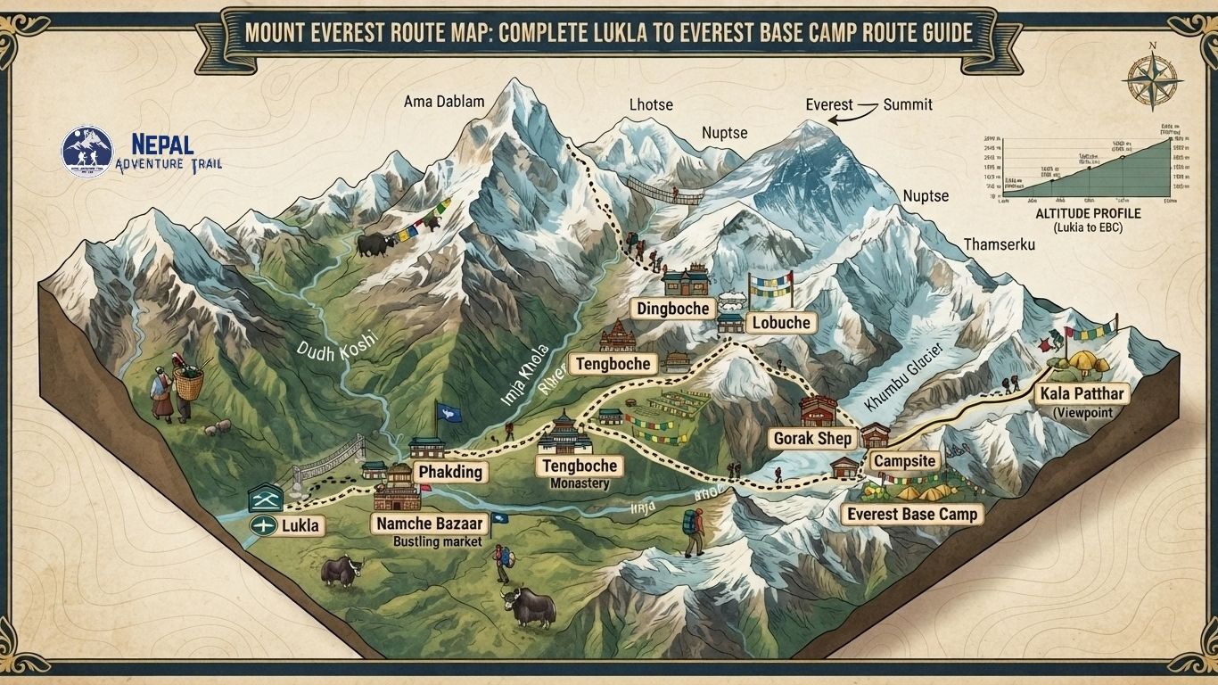
Mount Everest Route Map
The classic route runs north from Lukla up the Dudh Koshi valley, then east and north into the Khumbu valley, following one main trail with a few forks.
Kathmandu, Lukla, Phakding, Monjo, Namche Bazaar, Tengboche, Pangboche, Dingboche (or Pheriche), Lobuche, Gorak Shep, Everest Base Camp. Kala Patthar is a side climb from Gorak Shep, not a stop on the way to Base Camp.
Two points explain most of the map:
- Kathmandu is not where the walking starts. The trail begins at Lukla, about a 30 to 40 minute flight away, or on foot from Jiri or Salleri on longer approaches.
- Some itineraries sleep at Dingboche and others at Pheriche. Both sit in the same valley system and the routes rejoin before Lobuche.
Everest Base Camp Route at a Glance
| Route stop | Approx. elevation | Typical walking time | What to expect |
|---|---|---|---|
| Lukla | about 2,860 m | Start | Airstrip town, flight arrival, lodges and shops |
| Phakding | about 2,610 to 2,650 m | 3 to 4 hrs from Lukla | Easy first day along the Dudh Koshi, lodge stop |
| Monjo | about 2,840 m | 2 to 3 hrs from Phakding | Last village before the park gate area |
| Namche Bazaar | about 3,440 m | 5 to 7 hrs from Phakding | Main Sherpa market town, acclimatization stop |
| Tengboche | about 3,860 to 3,885 m | 5 to 6 hrs from Namche | Monastery, forest, Ama Dablam views |
| Pangboche | about 3,900 m | 2 to 3 hrs from Tengboche | Old Sherpa village on the way up the Imja valley |
| Dingboche | about 4,410 m | 5 to 6 hrs from Tengboche | Open valley, stone-walled fields, Imja Tse views |
| Pheriche | about 4,240 m | 5 to 6 hrs from Tengboche | Lower alternative stop, windier valley floor |
| Lobuche | about 4,940 m | 5 to 6 hrs from Dingboche | Sparse, cold, close to the glacier |
| Gorak Shep | about 5,140 to 5,180 m | 2 to 3 hrs from Lobuche | Last settlement, basic lodges |
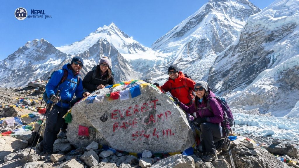
| Everest Base Camp | about 5,364 m | 4 to 5 hrs round trip from Gorak Shep | Moraine and glacier, seasonal expedition camp |
| Kala Patthar | about 5,545 m | roughly 2 to 3 hrs round trip from Gorak Shep | Rocky ridge, the best Everest viewpoint on the trek |
Elevations are rounded and differ by a few metres between sources. Walking times are typical ranges, not promises. Pace, weather and trail traffic change them.
Everest Route Map: Lukla to Everest Base Camp
Kathmandu to Lukla
Most trekkers fly. Flights to Lukla (Tenzing-Hillary Airport) leave early because wind and cloud build later in the day. During the peak months of March to May and October to November, many Lukla flights are operated from Manthali airport in Ramechhap, roughly 130 km east of Kathmandu, which means a very early road transfer from the capital. In quieter months, flights commonly leave from Kathmandu. Arrangements change, so confirm departure airport and timing with your operator close to your travel date.
Weather delays are common. Keep a spare day in the plan.
Lukla to Phakding
This is the gentle opening. The trail drops slightly and follows the Dudh Koshi valley through pine forest, stone-walled villages and prayer wheels. It is a short day, usually three to four hours, designed to settle you into walking at altitude.
Phakding to Namche Bazaar
The day feels different from the first. You pass Monjo and reach the Sagarmatha National Park entrance near Jorsale, where permits are checked. Several suspension bridges cross the river, including the high bridge below Namche. After the last crossing, the trail climbs steeply for a long stretch to Namche. Plan on 5 to 7 hours in total. This is the first real test of the trek.
Namche Bazaar Acclimatization
Namche is the town where most itineraries pause for a full day. Sleeping high and walking higher is the usual approach. Common acclimatization hikes go to the Everest View Hotel area above Syangboche, or to Khumjung and Khunde, then back to Namche to sleep. Rushing past Namche is a mistake. The altitude gain after it is steady and unforgiving.
Namche to Tengboche
A traverse along a hillside trail, with Ama Dablam, Thamserku and Kangtega in view. The path drops to the Imja Khola at Phunki Tenga, then climbs through forest to Tengboche, home to the region’s best-known monastery. Allow 5 to 6 hours. Distance is about 10 km.
Tengboche to Dingboche or Pheriche
The trail descends to Deboche, crosses the river, then climbs through Pangboche and into the Imja valley. Trees thin out. Juniper and scrub replace forest, and the valley opens wide.
Where the route splits matters. Dingboche sits at about 4,410 m on the Imja side. Pheriche sits lower, about 4,240 m, on the Pheriche valley floor. Itineraries choose one based on acclimatization design and direction of travel. Many trekkers sleep at Dingboche on the way up and Pheriche on the way down.
Dingboche or Pheriche to Lobuche
The valley merges near Thukla (Dughla). The climb up to the Thukla pass leads to a ridge lined with memorials to climbers and Sherpas who died on Everest and nearby peaks. Beyond it the terrain turns to glacial moraine. Lobuche is a cold, sparse stop at about 4,940 m. Allow 5 to 6 hours from Dingboche.
Lobuche to Gorak Shep
A short day in distance, about 4 to 5 km, and 2 to 3 hours of walking. The trail follows the lateral moraine of the Khumbu Glacier. There is no vegetation, strong wind and thin air. Gorak Shep, at roughly 5,140 to 5,180 m, is the last settlement.
Gorak Shep to Everest Base Camp
From Gorak Shep the trail crosses rocky moraine along the glacier to Everest Base Camp at about 5,364 m, then returns the same way. Expect 4 to 5 hours round trip. Base Camp is a seasonal expedition camp. It is occupied mainly during the spring climbing season and is largely empty at other times of year, so what you see depends on when you go.
You will not see the summit of Everest from Base Camp. Nuptse blocks the view. The icefall, tents and glacier are the sight.
Gorak Shep to Kala Patthar
Kala Patthar is a black rocky ridge above Gorak Shep, at about 5,545 m, and it is the standard viewpoint for Everest. It is not Everest Base Camp. Trekkers usually climb it at sunrise or late afternoon, then descend to Gorak Shep. From here you see Everest framed by Lhotse and Nuptse, with Pumori rising right beside you. A few sources give slightly different elevations for the ridge, so treat 5,545 m as approximate.
Everest Route Elevation Map
Distance is a poor way to read this trek. Altitude is the better way.
The profile in short: Lukla about 2,860 m, down to Phakding about 2,610 m, up to Namche about 3,440 m, Tengboche about 3,860 m, Dingboche about 4,410 m, Lobuche about 4,940 m, Gorak Shep about 5,160 m, Everest Base Camp about 5,364 m, Kala Patthar about 5,545 m.
Three features of the profile matter:
- The trek climbs about 2,500 m from Lukla to Base Camp. Most of the stress comes from sleeping altitude rather than daily gain.
- The route has two dips, Lukla to Phakding and Tengboche to Deboche. These add climbing back out.
- Above Dingboche the daily gain is small, but the air is thin. Short days there are deliberate.
Rest days at Namche and Dingboche are part of the map, not optional extras. Altitude illness can affect anyone, regardless of fitness. Headache, nausea and poor sleep are early signs. Worsening symptoms mean you stop climbing and descend. Descent is the treatment that always works.
Everest Trek Distance
Published figures vary. Many operators give about 130 km round trip from Lukla, around 65 km each way. Others measure about 115 km round trip, around 51 km one way. A third group gives about 123 km.
The differences come from how routes are measured. Some count GPS track length, others count map distance. Some include Kala Patthar and acclimatization hikes, and some count side trips to Khumjung or Gokyo. Treat anything between roughly 115 and 130 km as a reasonable round-trip estimate for the standard route.
How Many Days Does the Everest Route Take?
The standard itinerary is about 12 to 14 days from Kathmandu to Kathmandu, with around 11 days of walking and two acclimatization days.
Shorter versions exist, including those that fly back by helicopter from Gorak Shep or Lobuche. They cut the descent, but they do not change the ascent, so acclimatization timing still matters. Longer itineraries add extra days at Namche and Dingboche or combine EBC with Gokyo. Be wary of heavily compressed schedules. Faster is not better when altitude is the limiting factor.
Alternative Everest Trekking Routes
“Everest route” does not mean one trail.
- Classic Lukla to EBC: the route described above.
- Jiri to Everest Base Camp (Lower Solu): a longer walking approach from the road at Jiri, adding about a week through lower villages and ridges before joining the Lukla trail near Namche.
- Salleri / Phaplu approach: a road-access variation that starts further up the Solu valley, shortening the lower walk compared with Jiri.
- Gokyo Valley plus EBC: an extended route that adds the Gokyo lakes and Gokyo Ri, typically linked with Cho La pass.
- Everest Three Passes: a demanding extended circuit crossing Kongma La, Cho La and Renjo La. It is a separate trek, not a variation of the standard schedule.
Mountains Seen Along the Everest Route
Not every peak is visible from every stop.
- Ama Dablam, Thamserku and Kangtega: dominate the middle section, especially around Namche, Tengboche and the Imja valley. Ama Dablam stays in view for days.
- Everest, Lhotse and Nuptse: glimpses appear on the Namche to Tengboche trail, but Everest looks small and partly hidden behind the Nuptse-Lhotse wall.
- Pumori: grows large above Lobuche and Gorak Shep.
- Everest summit proper: seen clearly from Kala Patthar. It is not visible from Everest Base Camp.
Mornings are usually clearest. Cloud often builds by midday.
Major Villages on the Everest Route
Lukla. The traditional trekking gateway because of its airstrip. A working town of lodges, bakeries and gear shops.
Phakding. A lower valley village on the Dudh Koshi. Mostly lodges, used as the first overnight.
Namche Bazaar. The commercial and cultural hub of the Khumbu Sherpa community, built into a hillside bowl. Weekly market, bakeries, permit checks and the best chance of last-minute gear.
Tengboche. Site of Tengboche Monastery, the main Buddhist monastery in the region. Visitors should be quiet and follow local etiquette during ceremonies.
Pangboche. One of the older Sherpa settlements on the route, with a monastery also regarded as among the oldest in the area.
Dingboche. A broad valley village known for stone-walled barley and potato fields and a common acclimatization stop.
Pheriche. A windy valley settlement known for its seasonal aid post, run by a volunteer medical organization in peak months.
Lobuche. A high, spare stop. Lodges here are basic and nights are cold.
Gorak Shep. The last settlement. Lodges only, no permanent village.
Sagarmatha National Park and Trekking Permits
Sagarmatha National Park covers the high Khumbu and has been a UNESCO World Heritage Site since 1979. On the classic route, the park boundary is crossed on the way to Namche, with the entrance checkpoint near Monjo and Jorsale.
Commonly reported permits for foreign trekkers are:
- Sagarmatha National Park entry permit: about NPR 3,000, sold at the Nepal Tourism Board office in Kathmandu or at the checkpoint at Monjo.
- Khumbu Pasang Lhamu Rural Municipality permit: a local trekking permit, commonly reported at about NPR 2,000 for the first four weeks.
Together, operators typically quote around NPR 5,000 to 6,000. Taxes and handling can change the total.
Two rules need careful wording. Many sources state that a licensed guide booked through a registered agency has been required for foreign trekkers since 2023 in national parks and conservation areas, including Everest. On TIMS, sources disagree. Many operators say TIMS is not required for the standard Khumbu route because the local permit replaced it. Nepal Tourism Board’s published national guidance, as described in some current guides, still lists Everest Base Camp among routes under its guide and TIMS provision. The Sagarmatha park permit is not the same thing as a TIMS card. Because of this mismatch, confirm the current rule with Nepal Tourism Board or your agency before you travel.
Best Time to Follow the Everest Route
Spring (March to May). Longer days, warming temperatures and rhododendron blooms on the lower trail. This is also the main expedition season, so Base Camp is active and trails are busy. Haze can soften distant views.
Autumn (September/October to November). Typically the clearest skies and stable weather after the monsoon. Busy, with flights and lodges under pressure.
Winter (December to February). Very cold, with deep sub-zero nights at altitude, snow on higher sections and fewer open lodges. Skies can be sharp. Flights run in good weather.
Monsoon (June to September). Rain, cloud, leeches on the lower trail and frequent flight disruption. Views are poor. A route for those who want quiet and accept the trade-offs.
Spring and autumn are popular for reasons, not because other seasons are impossible. Choose based on whether you prioritise clarity, flowers, quiet or lower cost.
Everest Route Difficulty
Demanding but not technical. No climbing skills are needed.
The hard parts are cumulative. Long days of 5 to 7 hours, repeated steep ascents and descents, cold nights and thin air at the top. The climb to Namche is the first hard day. The push from Lobuche to Gorak Shep and on to Base Camp, and the Kala Patthar ascent, are the most physically demanding because of altitude. Descents are long and punishing for knees. Good fitness, steady pacing and adequate rest days matter more than speed.
Accommodation and Food
Teahouse lodges run the length of the route.
- Lukla, Phakding, Namche: the widest choice. Private rooms, some with attached bathrooms, and hot showers for a fee.
- Tengboche and Dingboche or Pheriche: simpler lodges, shared bathrooms, heating only in the dining room.
- Lobuche and Gorak Shep: basic, cold, often crowded in peak season. Rooms have no heating.
Electricity for charging is usually paid by the hour, and Wi-Fi is paid and unreliable. Menus are similar everywhere: dal bhat, noodles, rice, eggs, potatoes, soups and bread. Prices rise with altitude because everything is carried in. Drink plenty of fluids. Boiled or treated water avoids buying bottles, and a purification method reduces plastic waste.
What to Pack
- Broken-in waterproof trekking boots and spare socks
- Base layers, fleece, insulated down jacket
- Waterproof shell jacket and trousers
- Trekking trousers, gloves, warm hat, sun hat
- Sunglasses with UV protection and sunscreen
- Trekking poles
- Headlamp with spare batteries
- Sleeping bag rated for low temperatures (many lodges provide blankets, but not enough for winter)
- Water bottles and purification tablets or filter
- First-aid kit and personal medication
- Power bank, passport, permits, insurance documents, cash
In winter, add heavier insulation, thicker gloves and a warmer sleeping bag. In spring and autumn, a lighter set works, but nights above 4,000 m are still very cold.
Is the Everest Route Safe?
Reasonably safe for prepared trekkers, but not risk-free.
Altitude is the main concern. Weather changes quickly and flights are often delayed. Cold, dehydration and exhaustion add risk. Trails are well-marked, but snow or cloud can reduce visibility. Rescue is possible but depends on weather and location. Travel insurance that covers trekking above 5,000 m and helicopter evacuation is essential. Guides and porters add practical safety. Nobody can promise that a trek is completely safe.
Everest Base Camp Trek vs Everest Climbing Route
| Everest Base Camp trek | Everest mountaineering route |
|---|---|
| Trekking route | Expedition route |
| Ends at Everest Base Camp | Continues toward the summit |
| Trekkers | Mountaineering teams |
| Khumbu valley trail | High-altitude climbing route |
| Teahouse-based | Expedition camps |
| No summit climbing | Technical mountaineering |
The summit of Everest stands at about 8,849 m. The trekking route stops at roughly 5,364 m at Base Camp. Climbing teams continue through the Khumbu Icefall and up through higher camps. That is a separate, technical undertaking with its own permits and support.
How to Read an Everest Route Map
- Elevation markers: check sleeping altitudes first. They matter more than day-to-day totals.
- Route lines: the main trail is a single line with forks. Check which fork your itinerary uses, Dingboche or Pheriche.
- Villages: treat these as the real stops. Some small settlements are tea houses only.
- Peaks: peaks on a map are labelled, but views depend on weather and where you stand.
- Distances and times: scale and mapping method change distance. Walking times are typical, not exact.
- Side trails: acclimatization hikes and Kala Patthar are marked as spurs.
- Park boundaries: the Sagarmatha National Park line crosses the route before Namche.
Map Accuracy
Route maps are simplified. Trail conditions change after weather, landslides or bridge repairs. Exact distances differ by mapping method. Walking times vary with fitness and weather. Any illustrative route map made for this article should be labelled as illustrative, not an official government map. Confirm current trail conditions locally.
Responsible Trekking
- Carry out what you carry in. Waste handling at altitude is limited.
- Use a refillable bottle and purification instead of bottled water.
- Stay on established trails. Cutting switchbacks accelerates erosion.
- Walk clockwise around mani walls and stupas, and keep quiet in monasteries.
- Ask before taking photographs of people.
- Use local lodges, guides and porters, and treat porters fairly.
Trek the Everest Route with Nepal Adventure Trail
The Everest route involves a flight or early road transfer, permit checks, lodging choices that fill in peak season and acclimatization decisions that affect your safety. Nepal Adventure Trail can arrange the logistics: licensed guide coordination, permits, Lukla transport, accommodation, porter support and airport transfers. Itineraries can be adjusted for acclimatization, trip length and group or private travel.
Which itinerary fits whom: a standard 12 to 14 day plan suits most first-time trekkers, a helicopter return suits those short on time, and Gokyo or Three Passes extensions suit experienced trekkers with more days.
Everest Route Frequently Asked Questions
What is the Mount Everest route map?
The Mount Everest route map usually means the trekking map of the Everest Base Camp trail from Lukla. It shows the sequence of villages, approximate elevations, side trails such as Kala Patthar and the national park boundary. It is not a summit climbing map. The trekking route ends at Base Camp, around 5,364 m, while the summit is roughly 8,849 m.
Where does the Everest Base Camp trek start?
The classic walking route starts at Lukla (about 2,860 m), reached by a short flight from Kathmandu or from Manthali airport in Ramechhap during busy months. Some longer itineraries start on foot from Jiri or Salleri, which adds days through the lower Solu valley. Kathmandu is the travel base, but the walking trail itself begins at Lukla for most trekkers.
What is the route from Lukla to Everest Base Camp?
The route runs Lukla, Phakding, Monjo, Namche Bazaar, Tengboche, Pangboche, Dingboche or Pheriche, Lobuche, Gorak Shep and Everest Base Camp. Kala Patthar is a separate climb from Gorak Shep. The trail follows the Dudh Koshi valley, then the Imja and Khumbu valleys. Acclimatization days at Namche and Dingboche are built into most schedules.
How many days does the Everest route take?
Most standard itineraries take about 12 to 14 days from Kathmandu to Kathmandu, with around 11 days of walking and two acclimatization days. Helicopter-return versions are shorter, and Gokyo or Three Passes extensions are longer. Compressed schedules save time but raise altitude risk, so extra days are worth planning, especially around Namche and Dingboche.
How far is Everest Base Camp from Lukla?
Sources vary. Many give about 65 km one way and 130 km round trip. Others measure about 51 km one way and 115 km round trip, and some land near 123 km. The difference comes from measurement methods and whether side hikes are counted. A fair planning range is 115 to 130 km for the round trip.
What villages are on the Everest Base Camp route?
Main stops are Lukla, Phakding, Monjo, Namche Bazaar, Tengboche, Pangboche, Dingboche or Pheriche, Lobuche and Gorak Shep. Jorsale and Deboche are smaller stops on the way. Namche is the largest and most developed. Above Dingboche, villages become seasonal clusters of lodges, and Gorak Shep is the final settlement before Base Camp.
What is the highest point on the Everest Base Camp trek?
Everest Base Camp sits at about 5,364 m, but Kala Patthar, the optional viewpoint above Gorak Shep, reaches about 5,545 m and is the highest point most trekkers reach. Some sources quote slightly different figures for both. Sleeping altitude is highest at Gorak Shep, around 5,140 to 5,180 m, and that is where many people feel the altitude most.
Is Mount Everest visible from the trekking route?
Yes, in parts. Glimpses of Everest appear on the Namche to Tengboche trail, though it looks small behind the Nuptse-Lhotse ridge. The best view is from Kala Patthar, where Everest stands clearly beside Lhotse and Nuptse. It is not visible from Everest Base Camp itself, because Nuptse blocks the view. Mornings give the clearest conditions.
What permits are needed for the Everest Base Camp trek?
Commonly reported permits are the Sagarmatha National Park entry permit, about NPR 3,000, and the Khumbu Pasang Lhamu Rural Municipality permit, about NPR 2,000 for the first four weeks. Reports on TIMS differ, so confirm the current requirement with Nepal Tourism Board or your agency. A licensed guide booked through a registered agency is widely reported as mandatory for foreign trekkers.
Can you trek the Everest route without a guide?
Under the rule widely reported since 2023, foreign trekkers in Nepal’s national parks, including Sagarmatha, must use a licensed guide through a registered agency. Some older articles still describe independent trekking, but those predate the rule. Confirm the current position with Nepal Tourism Board or your agency before planning. A guide also helps with weather decisions, altitude monitoring and logistics.
What is the best season for the Everest Base Camp route?
Spring and autumn are most popular because of more stable weather and better visibility, but each has trade-offs. Spring brings rhododendrons and an active Base Camp but some haze. Autumn usually has the clearest skies but heavy traffic. Winter is cold and quiet, and monsoon brings cloud, rain and flight disruption. Choose based on your priorities.
Is the Everest Base Camp route the same as the Everest climbing route?
No. The trekking route ends at Everest Base Camp, about 5,364 m. The climbing route continues through the Khumbu Icefall and higher camps toward the summit at roughly 8,849 m. It is technical mountaineering with expedition support and separate permits. The trekking route is teahouse-based and needs no climbing skills, but it is still demanding because of altitude.
Conclusion
The Mount Everest route map is easiest to read as an altitude story. One main trail climbs from Lukla through Sherpa villages to a glacier camp at 5,364 m, with Kala Patthar as the viewpoint that finally shows Everest properly. Plan around acclimatization, confirm permit and guide rules shortly before departure, keep a spare day for flights and choose a season that matches what you want from the trek.