
The Badimalika trek does not appear on the standard Nepal itinerary. Most agencies never mention it. That silence is the first honest thing anyone can tell you about this route.
This is a pilgrimage path first and a trekking route second, climbing through Bajura district in Nepal’s far west toward a stone shrine above 4,200 meters. Red mud trails replace the paved stairways of Everest and Annapurna. Ridge winds replace tea shop small talk. Anyone researching the Badimalika trek needs to understand it as a study in contrast: raw geography, deep Hindu mythology, and logistics that have not yet been smoothed over for tourism.
The Badimalika temple Bajura pilgrims visit each year sits at the physical edge of what most trekking agencies consider serviceable. That edge is exactly why the route matters. It rewards patience, punishes assumptions, and offers something the crowded eastern circuits stopped offering years ago: genuine solitude.
Trekkers who complete the Badimalika trek rarely describe it as scenic in the postcard sense. They describe it as heavy, in the way a place feels when thousands of people have walked the same mud for centuries, carrying the same hope. That weight is the actual product here, more than any mountain view.
The Far-Western Frontier: Why Badimalika Remains Untamed
Far-Western Nepal trekking exists in a different category from the rest of the country’s trail network. Bajura sits roughly 700 kilometers from Kathmandu by road, tucked against the edge of Sudurpashchim Province. Few foreign trekkers make the trip. Even fewer finish it.
The terrain resists comparison. Villages thin out fast once the trail leaves the district headquarters at Martadi, and the trekking infrastructure common in Solukhumbu or Manang simply does not exist here. There are no bakeries selling apple pie at 3,000 meters. There are no signposted junctions every kilometer.
That absence of infrastructure is the whole point for a certain kind of traveler. Remote trekking in Nepal has become harder to find as roads push into once-isolated valleys across the Annapurna and Everest regions. Bajura has largely escaped that road expansion, and the trail still moves at the pace it always has: on foot, through mud, past villages that see foreigners rarely enough to remember them by name.
Bajura’s population lives mostly by subsistence farming, a fact that shapes every part of the trekking experience here. Terraced fields of millet and barley climb the lower hillsides in narrow steps. Buffalo work the terraces where machinery cannot reach. Children walk long distances to school, often on the same paths trekkers use to reach the trailhead, and the line between “trail” and “someone’s daily commute” disappears almost entirely below 2,500 meters.
Poverty and remoteness sit close together in this district. Bajura regularly ranks among Nepal’s least developed districts by government indices, and food security remains a real concern for households outside the harvest months. Trekkers moving through should carry the awareness that this is not a manufactured wilderness experience. It is someone’s home, under genuine economic strain, and the trail simply happens to pass through it.
Geography of the Bajura District and the Remote Trails
Bajura’s terrain climbs from around 300 meters near its lowland edges to more than 6,400 meters at its highest ridgelines, a vertical range most districts in Nepal cannot match. That span produces five distinct climate zones inside a single administrative boundary. Subtropical rice terraces give way to temperate pine within a day’s walk.
The trail itself is unforgiving in a specific way. Red laterite mud coats the lower paths after monsoon rain, turning switchbacks into slick, ankle-deep channels. Stone steps appear occasionally near villages, laid generations ago and rarely repaired. Above the treeline, the ground turns to loose scree and packed earth, and the wind starts to matter more than the altitude gain.
Forest cover along the middle elevations consists mostly of pine, oak, and rhododendron, the same species that draw crowds to Annapurna’s Ghorepani ridge each spring. Here, the same rhododendron bloom passes without a single trekking group to photograph it. Leopard, Himalayan black bear, and musk deer still range through these forests, animals that have become rare or absent along the busier eastern trails.
Martadi, the district headquarters, sits at roughly 2,030 meters. It functions as the last real town before the trail commits fully to wilderness. Past Martadi, mobile signal drops out. Shops disappear. The Badimalika trek becomes, in the truest sense, a walk into infrastructure absence.
Between Martadi and the upper Patans, the trail passes through a handful of villages worth naming for planning purposes: Kolti, Chhatara, and Gothalapani among them. Each offers a place to sleep, though “offers” is generous. A private room is rare. A shared floor near a wood stove is the realistic baseline, and trekkers who expect otherwise will be disappointed early.
Weather on the ridgelines above Martadi shifts fast and without warning, a pattern trekkers underestimate at their own cost. Clear morning skies can close into driving rain by early afternoon. Wind funnels through the passes with enough force to knock a walking pole sideways. Layering matters more here than on almost any other trekking route in Nepal, precisely because there is no teahouse fire waiting at the next bend to dry out wet gear.
Annapurna Circuit permits and Everest Base Camp registration have become routine paperwork exercises, processed by staff who handle hundreds of applications a week. Bajura’s district offices see a fraction of that volume. Expect slower processing, more manual record-keeping, and officials who may need extra context on why a foreign trekker wants to walk toward Badimalika at all.
The Sacred Geography: Temples, Lakes, and the 22 Patans
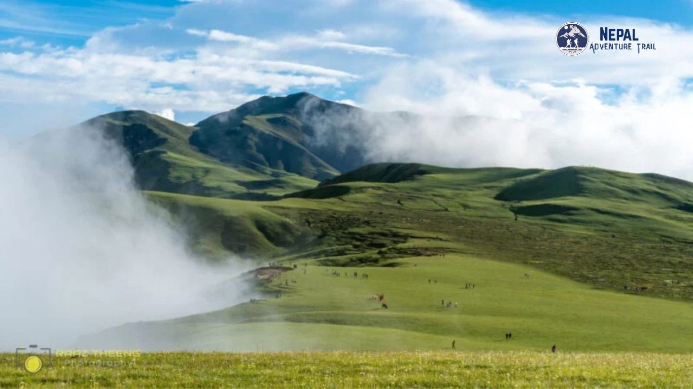
Badimalika’s landscape is organized around sacred geography, not scenic viewpoints. Local tradition names 22 separate Patans, high alpine meadows scattered across the approach to the temple. Each Patan carries its own name, its own small shrine or resting point, and its own place in the pilgrim’s mental map of the route.
Mist moves across these Patans in slow sheets most mornings, thick enough to erase the ridgeline ahead. It burns off by midday. Then it comes back by late afternoon, right on schedule.
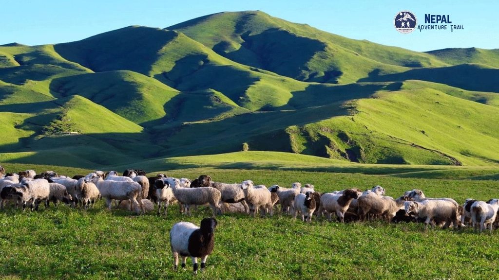
Grass covers most of these meadows rather than forest, a result of elevation and exposure rather than deforestation. Yaks and local livestock graze here during the warmer months, tended by herders who split their year between lowland villages and these high pastures. The 22 Patans function as waypoints, campsites, and grazing ground all at once, a layered use of land that predates any concept of trekking tourism.
Each Patan has its own microclimate, shaped by which direction it faces and how exposed it sits to the prevailing wind. Some hold pockets of standing water well into the dry season. Others turn hard and cracked by October. Local guides read these meadows the way a sailor reads a coastline, matching each one to a specific season and a specific mood.
Triveni Patan and Malika Daha
Triveni Patan holds particular weight among the 22, sitting at the confluence point pilgrims traditionally purify themselves at before continuing upward. The name itself, Triveni, refers to a meeting of three streams, a detail pilgrims repeat like a checkpoint marker. Bathing here is not optional for observant travelers. It is the ritual gateway to everything above.
The water at Triveni runs glacial cold even in summer, fed by snowmelt higher on the ridge. Pilgrims wade in anyway, often at dawn, breath visible in the thin air. Prayer flags strung along the banks snap hard in the crosswind. Nobody lingers long in the water itself, but almost everyone stops here.
Malika Daha, the alpine lake near the upper reaches of the route, holds a different kind of reverence. Locals treat the water as sacred, tied directly to the goddess the entire pilgrimage honors. The lake sits exposed to ridge winds, its surface rarely still. Anyone trekking Triveni Patan Badimalika en route to the lake should expect a cold camp and a colder morning.
Ice can form at the lake’s edges outside the summer months, a detail few trip reports mention. Pilgrims still bathe here regardless of temperature, a practice that speaks to how central the ritual remains. Photographs rarely capture how loud the wind gets at this elevation. Standing beside Malika Daha at dawn, the sound alone tells you how far you’ve walked from anything resembling shelter.
The lake basin sits in a natural bowl below the final ridge to the temple, a shape that traps cloud and fog on most afternoons. Trekkers arriving after midday often see nothing but white. Those who camp overnight and wake before sunrise sometimes get a clear thirty-minute window before the mist rolls back in. Guides plan the final push around that window whenever the weather allows it.
The Mythology of Sati Devi and the Shrine
Badimalika’s origin story runs through the older, wider Hindu Shakti Peeth tradition. According to the legend, Sati Devi’s father excluded her husband Shiva from a major yagya ceremony. Sati, unable to bear the insult, threw herself into the sacrificial fire. As her body fell across the subcontinent, each landing point became a place of worship, a Shakta Pitha.
One shoulder fell on Mallagiri mountain. Over time, the name shifted, and Mallagiri became Malika. That single mythological detail explains why a stone shrine sits above 4,200 meters in one of Nepal’s least accessible districts. It also explains why two separate priests, one representing Bajura and one representing neighboring Kalikot, jointly serve the temple to this day.
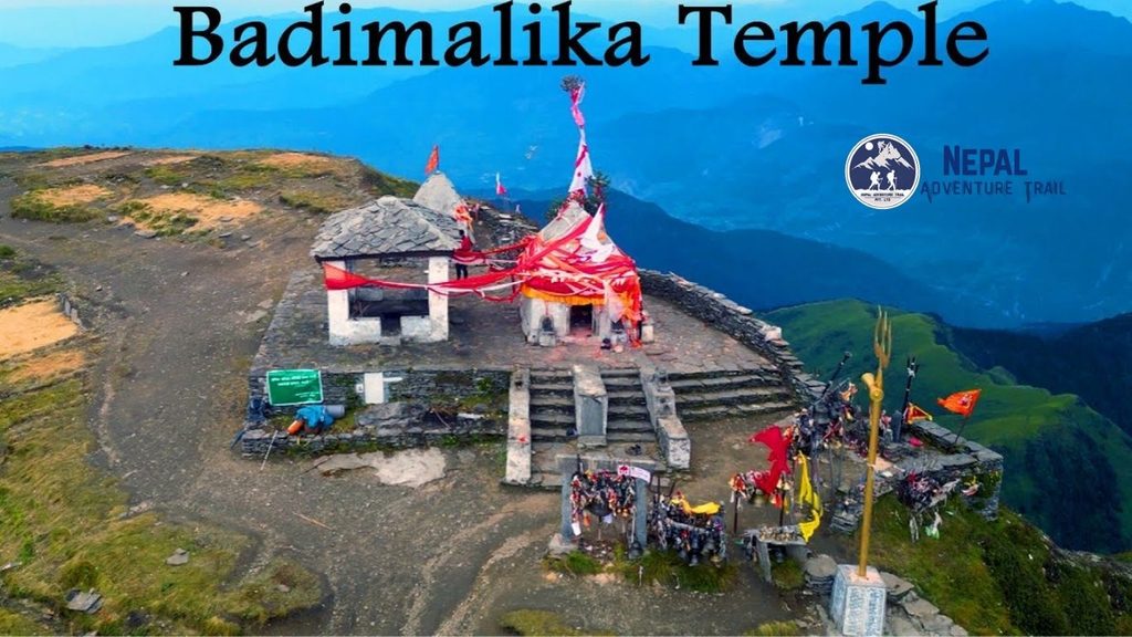
The shrine itself is modest. Pagoda-style, weathered, wrapped in prayer bells that ring constantly in the wind. Pilgrims leave red cloth, vermillion powder, and coins. There is no gift shop. There is no ticket booth. There is only the bell sound and the cold.
Two priests still alternate service at the temple, one drawn from Bajura and one from neighboring Kalikot district, a tradition that has held for generations. That shared custodianship reflects how the pilgrimage draws from a wider region than Bajura alone. Devotees from Karnali Province and beyond consider Badimalika their goddess as much as anyone born in Triveni Municipality does.
Malika Chaturdashi, observed on the fourteenth day of the lunar month, marks the temple’s primary festival outside of Janai Purnima itself. Local families time entire agricultural calendars around it, scheduling planting and harvest to allow time for the journey. That kind of calendar-shaping is rare even among Nepal’s more famous pilgrimage sites, and it says something about how deeply the goddess is woven into daily life in this district.
Stories collected from local priests add texture beyond the core myth. Some describe the temple bell ringing on its own during storms, a phenomenon attributed to the goddess signaling her presence. Whether or not a visitor takes that literally, the bell does ring constantly in the wind at this altitude, and standing there during a storm, the line between wind and something else becomes genuinely hard to draw.
The Annual Pilgrimage vs. Independent Trekking
The Badimalika pilgrimage route sees two very different kinds of travelers. Most are Hindu pilgrims arriving in a specific narrow window each year. A much smaller number are independent trekkers coming for geography, culture, or the challenge of an unspoiled route.
Both groups face the same trail. They do not face the same crowd, the same logistics, or the same experience of the temple itself.
Janai Purnima: When the Wilderness Comes Alive
Once a year, on Janai Purnima, the far-western wilderness fills with people. Thousands travel from across Nepal and from northern India specifically for this pilgrimage, converting an otherwise empty ridgeline into a moving column of red-clad devotees. Camps appear across the Patans overnight. Fires burn along the trail after dark.
The scale surprises most first-time visitors. A route that sees almost nobody for eleven months suddenly hosts a temporary tent city. Sadhus arrive from distant parts of the country. Local families walk multiple days carrying children and offerings. Malika Chaturdashi, the temple’s major festival, anchors the entire event around belief in wish fulfillment at the shrine.
Trekking during Janai Purnima means accepting crowds, competition for camp space, and a completely different pace than the rest of the year. It also means witnessing something almost no foreign trekker in Nepal ever sees.
Food stalls appear temporarily along the lower trail during the festival, run by families who set up for these few days only and pack up immediately after. Prices rise. Water sources see heavier use. None of that changes the core character of the pilgrimage, which remains devotional rather than commercial, even at its busiest single moment of the year.
The physical rhythm of the crowd changes the trail itself during these days. Sections that stay quiet and slow in normal season turn into a shuffling queue, single file, moving at the pace of the slowest elderly pilgrim ahead. Trekkers used to setting their own pace need to adjust expectations. This is not a route to rush during festival week, and trying to pass creates friction nobody benefits from.
Sound carries differently across the Patans during the festival than at any other time. Conch shells sound from multiple camps at once in the pre-dawn hours. Devotional chanting drifts across the meadows, overlapping from different groups walking at different speeds. It is, by a wide margin, the loudest this landscape ever gets, and the contrast with its usual silence is part of what makes the experience memorable.
Solo and Guided Logistics in an Infrastructure Desert
Outside the festival window, Badimalika trekking logistics shift entirely. The trail empties. Teahouses, where they exist at all, may not be staffed. Solo trekkers face real risk here, not from technical terrain, but from isolation itself. A twisted ankle two days from Martadi is a serious problem with no easy fix.
Guided groups carry their own advantage in this specific district. Local guides know which villages still have functioning teahouses in a given season, which stream crossings turn dangerous after rain, and which Patans offer shelter from ridge winds. That knowledge does not exist in any app or downloadable map. It lives with people who have walked the route for years.
Porters familiar with the Badimalika pilgrimage route also carry practical knowledge about pacing. They know which sections demand a slow, deliberate climb and which stretches can be covered quickly before weather turns. That pacing sense, built from repetition rather than guidebooks, often matters more than fitness level alone.
Communication is the single biggest gap solo trekkers underestimate. Mobile networks disappear past Martadi for long stretches, and satellite devices are not standard gear for most independent travelers attempting Nepal treks. Anyone trekking without a guide needs a clear check-in plan with someone back home, a realistic emergency evacuation budget, and no illusions about how quickly help could reach a remote Patan if something went wrong.
Language adds another layer. English is not common past Martadi, and even standard trekking Nepali only goes so far in villages where local dialects dominate daily speech. A guide who speaks the regional dialect resolves problems before they start, from finding a place to sleep to negotiating a fair price for food in a village with no fixed rates.
Practical Trekking Logistics and Route Realities
Planning the Badimalika trek requires more preparation than most Nepal treks, precisely because so little has been built around it. Permits, transport, and accommodation all demand advance thought rather than on-the-ground improvisation.
A realistic itinerary runs longer than most trekkers expect going in. Budget at least ten to twelve days total once flights, road transfers, trekking days, and weather buffers are added together. Compressing the schedule tighter than that leaves no margin for the flight delays and weather closures that happen routinely in this district.
Permits, Local Guides, and Teahouse vs. Camping Realities
Trekkers need to register with local authorities and, depending on current regulations, secure a TIMS-equivalent permit through the district administration. Rules shift more often here than in the major trekking regions, so checking current requirements close to departure matters.
Accommodation splits into two unreliable categories. Basic teahouses exist in a handful of villages, but bedding, food variety, and even opening hours vary by season and by whether the owner happens to be away. Camping fills the gap above the treeline and during the off-season. That means carrying a tent, a stove, and enough food for stretches where no resupply exists.
Gear planning deserves more attention here than on Nepal’s mainstream routes. A four-season tent, a sleeping bag rated well below freezing, and a reliable water filtration system are not optional extras. They are baseline requirements once the trail passes the last reliable teahouse below the Patans. Fuel for cooking must be carried in, since no established resupply point exists along the upper trail.
Food along the route is basic and repetitive: dal bhat, local millet dishes, potatoes, and whatever the season’s harvest allows. Trekkers with dietary restrictions or strong preferences should carry supplementary food from Kathmandu, since substitution options simply do not exist in villages this small. Water sources are plentiful but require treatment, and boiling is often more reliable than filtration given how silty the streams run after rain.
Altitude adds its own layer of risk. The shrine sits above 4,200 meters, high enough for altitude sickness to become a genuine concern for trekkers moving too fast from Martadi’s lower elevation. Acclimatization days are not a formality on this route. They are a requirement. Symptoms to watch for include persistent headache, nausea, and unusual fatigue, and the correct response to any of them is the same as anywhere else in the Himalaya: stop ascending, and descend if symptoms worsen.
Costs run lower than the major circuits in daily terms but higher in logistical overhead. Domestic flights to the far west carry a premium over routes to Pokhara or Lukla, and jeep hire for the overland legs is priced by the trip rather than the seat. A realistic guided budget should account for flight volatility, since cancelled flights often mean an unplanned night in Nepalgunj or Dhangadhi waiting for the next weather window.
Access: Flights to Dhangadhi or Bajura and Overland Realities
For anyone searching how to get to Badimalika temple from Kathmandu, the honest answer involves multiple legs and no shortcuts. Most trekkers fly first to Nepalgunj or Dhangadhi, then connect onward to Bajura Airport, a short domestic strip serving the district. From there, jeep or foot travel covers the remaining distance to Martadi and the trailhead.
Overland travel from Kathmandu is possible but grinding, often stretching across two full days of rough road before the trek even begins. Weather closes the small Bajura airstrip regularly, so flight schedules need buffer days built in, not assumed as fixed.
The jeep leg between Bajura Airport and Martadi covers rough, unpaved sections that turn to churned mud in the rains and thick dust in the dry months. Vehicles here take a beating, and drivers navigate switchbacks with drop-offs that would draw far more attention on a busier tourist route. This is not a stretch to rush, and travelers should build in flexibility for delays caused by landslides or vehicle breakdowns, both of which happen with some regularity on this road.
As for the best time for Badimalika trekking, most experienced local guides point to the pre-monsoon window in spring and the post-monsoon window in autumn, when trails are driest and visibility across the Patans holds longest. Winter brings snow and closes higher sections entirely. Monsoons turn the lower red mud trails into a genuine hazard.
Autumn carries the added advantage of clearer long-distance views across the Patans toward the higher Himalayan ridgeline to the north, a payoff that rewards trekkers willing to accept the shorter daylight hours that come with the season. Spring brings rhododendron color to the middle elevations and generally milder temperatures at the lower villages, though upper sections can still hold snow well into April in a heavy winter year.
Ready for the Far-Western Frontier
Badimalika is not a casual holiday; it is a raw, high-altitude journey into the physical and spiritual heart of Far-Western Nepal. Navigating the absence of commercial teahouses and complex regional logistics requires an experienced partner. At Nepal Adventure Trail, we provide the deep regional expertise, safety margins, and logistical backbone needed to experience the Badimalika trek with total confidence.